| Author |
Anyone know which road is this? |
QVGA
Joined: May 23, 2006
Posts: > 500
From: Pakistan
PM, WWW
|
http://pakwheels.com/images/f[....]_roads2_LD4_PakWheels(com).jpg
| |
|
fatreg
Joined: Jul 26, 2003
Posts: > 500
PM |
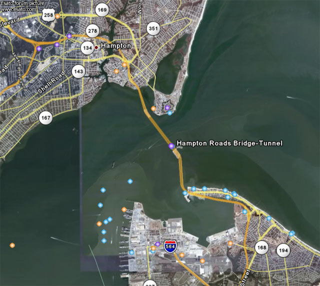
http://en.wikipedia.org/wiki/[....]errimac_Memorial_Bridge-Tunnel
it's that 
|
blackspot
Joined: Sep 06, 2004
Posts: > 500
From: Philippines
PM |
Found it in google earth too! 
resistance is futile. |
QVGA
Joined: May 23, 2006
Posts: > 500
From: Pakistan
PM, WWW
|
thanks you too. that place is awesome, wish i could have a drive in there
|
Nekeura
Joined: Mar 30, 2009
Posts: 0
PM |
Monitor-Merrimac Memorial Bridge-Tunnel (MMMBT) is the 4.6 mile-long (7.4 km) Hampton Roads crossing for Interstate 664. It is a four-lane bridge-tunnel comprised of bridges, trestles, man-made islands, and tunnels under a portion of the Hampton Roads harbor where the James, Nansemond, and Elizabeth Rivers come together in South Hampton Roads, in the southeastern portion of Virginia in the United States.
It connects the independent cities of Newport News on the Virginia Peninsula and Suffolk in South Hampton Roads and is part of the Hampton Roads Beltway
Interstate 664 is the 20.7-mile-long freeway that connects I-64 in Hampton to I-64/I-264 in Chesapeake, completed in April 1992. I-664 includes the 4.6-mile Monitor-Merrimac Memorial Bridge-Tunnel (MMMBT). The MMMBT cost $400 million to build, and it includes a four-lane tunnel that is 4,800 feet long, two man-made portal islands, and 3.2 miles of twin trestle. Northbound on the MMMBT is one of the most spectacular views on any road I know of; Hampton Roads makes a "V" with one branch to your ten o'clock, and the other branch to your two o'clock. You see an enormous expanse of water, left, right, and ahead of you, with the landfall of the Peninsula dead ahead. On the ten o'clock branch, you see the Newport News Marine Terminal and Shipyards, on the two o'clock branch, you see the Norfolk Naval Base. Typically, you will see a couple Nimitz-class aircraft carriers moored in the distance, and many other ships. Another nice feature, is that the MMMBT is toll-free. The name comes from the fact that the duel between the two Civil War ironclads was fought less than a mile from the where the tunnel is today.
http://images.google.com.sg/i[....]ng%2Broads%26gbv%3D2%26hl%3Den
|
pmerryman
Joined: Jun 02, 2004
Posts: > 500
From: Oldham,Uk
PM |
Thanks for joining a mobile phone forum, just to tell us what we already knew.
One Day, Men Will Look Back And Say I Gave Birth To The 20th Century. You have to have a piss in the sea, its the law. The A-Z of Trusted Traders[img]http://a-zott.com/images/A-Z | |
|
Access the forum with a mobile phone via esato.mobi
|


 Posted: 2007-12-06 08:02


