| Author |
k750i GPS |
dac0braman
Joined: Sep 25, 2005
Posts: 4
PM |
Hello people,
I have had a k750i for a few months now (and a bluetooth GPS receiver)... and have just discovered that it is possible to connect the two together.
What I need is an app for my phone that displays something like speed, distance, etc, I know this is possible since you can get apps which give you directions, position, maps, etc... but I only want something simple, I would expect it to do dead easy to do if you can program in J2ME, which i don't. But surely someone out there has made one for proof of concept etc? |
|
|
neonismo
Joined: Oct 18, 2002
Posts: 254
From: Melbourne, Australia
PM |
I've been doing a bit of research in this area. The Bluetooth GPS outputs standard NMEA text, so it's simple to write an app to retrieve the Lat & Long co-ords from the serial port. If you're looking for a more sophisticated app with speed, baring, tracklogs, maps - you'll need a dedicated piece of software. The only ones I know of are for Symbian and Windows Mobile.
This message was posted from a K700i |
jcwhite_uk
Joined: Feb 18, 2004
Posts: > 500
From: Dorset, UK Phone:Xperia Z1
PM, WWW
|
Check this thread:
K750i & GPS Software Working
Checkout my photos at My Website"Duct tape is like the force. It has a light side, a dark side, and it holds the world together." |
dac0braman
Joined: Sep 25, 2005
Posts: 4
PM |
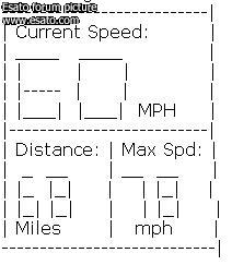
Well if anyone out there fancies making one (which i doubt it) this is what I would want:
Display Speed
Distance Travelled
Maximum Speed Travelled
A Nice Big-ish Text GUI Like This
a few other things would be nice but not essential like distance/fuel ratio (a simple way to work this out would be to ask the user when they fill the tank and ask them again to tell the prog when the tank is half empty, and calculate it that way). Thx for the link jcwhite_uk but I have already seen it, they are a bit more than want I need.
edit: the ascii didn't quite work so I took a screenshot and repsoted
[ This Message was edited by: dac0braman on 2006-01-18 01:01 ] |
jcwhite_uk
Joined: Feb 18, 2004
Posts: > 500
From: Dorset, UK Phone:Xperia Z1
PM, WWW
|
I must admit that a program like what you describe would be nice. I have Tomtom on my Imate PDA2K for proper sat nav but a basic speed and compass program for my W800i would be great.
Checkout my photos at My Website"Duct tape is like the force. It has a light side, a dark side, and it holds the world together." |
dac0braman
Joined: Sep 25, 2005
Posts: 4
PM |
Well since i am not the only one wanting this, how about we all get together and get some one to make one??? It must be dead simple to do if you have the knowledge, I would be willing to put in �10(GBP) anyone else gonna add, if we have a few ppl offer and someone see's the post we might just get someone to make something good |
japichardo
Joined: Dec 11, 2005
Posts: 41
PM |
Hi,
Check out this application.
http://www.unteh.com/products/mobitrack/details.html
It actually works with my w800i.
|
|
|


 Posted: 2006-01-18 00:32


